Concealed around the back of South Lismore is one of the least-known and largest parks in the local area. The Duck Pond is a 10.4-hectare green space bordered by Union Street, Casino Street, and Ostrom Street on three sides, with Leycester Creek marking the fourth boundary. A short walk from the Lismore CBD, the most direct pedestrian access is around the back of Frank Vanz Tyres on Union Street, via a track leading around to the left and down a flight of stairs.
Being low-lying and flood-prone, the Duck Pond was never subject to any permanent development, but nevertheless has an intriguing history of human use. Following European settlement, it made up a portion of the Twickenham estate, owned by Henry Garrard. Later, at times of flood, hoop pine logs were floated downstream, and were stored there before being transported on to Dorrough’s sawmill in North Lismore, in the area where Pritchard Park is today.
The Duck Pond was used for grazing cattle, and even as a sports ground during the 1920s and 1930s, for rugby league matches and inter-district cricket. In the 1940s, a dirt track was utilised for speedway competitions involving vehicles and motorcycles before this was closed due to safety concerns.

During part of the 1990s, the Duck Pond had an active Landcare-style group. Then, some time around the mid-2000s, the dreaded coral trees arrived, and within a few years had taken over. A fast-growing invasive species originating from South America, these have the tendency to crowd out other vegetation and form a thick impenetrable belt.
I discovered most of this hidden history from Derek Goodwin. A South Lismore local, he spent years single-handedly clearing rubbish and weeds from Hollingworth Creek, an intermittent waterway that flows into the Wilsons River a kilometre or so south of here. In early 2013, he switched his attention to the Duck Pond, and has joined up with a team of volunteers to transform this area, in an ongoing community effort. A bridge has been built to cross a shallow gully, large swathes of vegetation have been cleared, and native trees have been planted including over 1,300 plantings on National Tree Day in July this year.
For vehicle parking, the best access is via Ostrom Street, with the entry coming up on the right before you reach the mature Moreton Bay fig trees towards the end of the road.
My previous experience with the Duck Pond was to cross it on foot about fifteen years ago, at a time when, unlike today, there were no council park signs at the entrance. It contained grassy vegetation that was an effort to walk through, and an owl flew away at my approach.
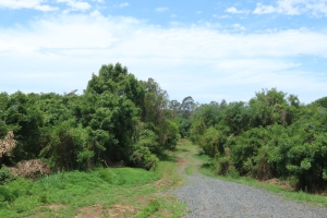
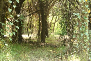
Today the western area of the park closer to the Ostrom Street entrance is an interesting mix of green pathways winding between islands of remnant jungle largely consisting of coral trees, balloon vine and morning glory.
The coral trees are flowering with their distinctive red colour, but the purple morning glory flowers, which are more prolific, dominate the scene. Over time, this invasive growth will be replaced with native plantings interspersed with walking tracks.
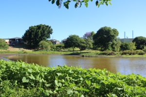
A track runs to the left, indicating the most direct way to the creek. Further on, another path on the right is signed towards the duck pond from which the area drives its name. The water level, which is periodically replenished by rain and flooding, is a low at the moment. Approaching the pond, ducks and white ibises fly up at my approach, but soon settle down to wading and hunting for food in the shallows. A healthy number of bird species are encountered here, including the royal spoonbill and rare black-necked stork, or jabiru. A full list of species is here.
This area backs onto the commercial and residential buildings of Casino Street. Mowed lawns run down the slope, and there is evidence that this spot holds an appeal for those fortunate enough to back onto it. A picnic bench, a seat, and two wrought iron chairs are visible on the other side. A wind-driven propeller mobile makes a musical clacking noise.
In the 1920s, one of the buildings along this stretch was the Fair Dinkum Café, an establishment owned by Greeks, and the pond was a popular swimming hole for Lismore’s young Greek community. During the Depression era of the 1930s, it was a camping spot for swaggies, who built informal shelters nearby. In the late 1940s, Richmond River Gun Club had a clubhouse located at the present site of Minarelli Smash Repairs, and would fire over the pond, apparently well above head height.
Back to the central track, the vista opens out into a wide open parkland area edged by some native plantings, complementing others just inside the Ostrom Street entrance. This area is intended to remain an open meadow where children can play. At the edge, a few large coral trees have been temporarily retained, providing bird habitat until the new growth comes up, and offering shade to several picnic tables below.
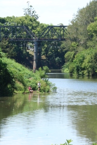
From here, there is a good vantage point for appreciating Leycester Creek as it sweeps around to the north to where it is crossed by the disused steel railway bridge. Two boys are fishing on the far side.
The Duck Pond-side bank descends to a gently sloping shelf just about the water level. Although it is hard to imagine today, this area was once a sandy beach that was later buried under mud.
In the 1920s and 1930s, this spot was a bathing mecca, and home to swimming races organised by Lismore City Council. Cordoned off behind a neat white picket fence was a group of dressing sheds where, in those more modest days, participants could change into their swimming costumes. These structures were swept away in one of Lismore’s many floods. In its heyday, on one afternoon council staff counted about three hundred bathers.
During the 1980s, a feasibility study was conducted for an inland marina at this spot, but it fizzled out due to a lack of interest.
Derek mentions another interesting local history connection with this spot. Until as recently as just fifteen years ago, sand was mined along the Wilson River near Wyrallah, and then transported here in barges. When the industry packed up, a couple of barges were simply abandoned. One is hidden from view in a thicket of mulberry trees, but another is accessible if you know where to look.
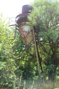
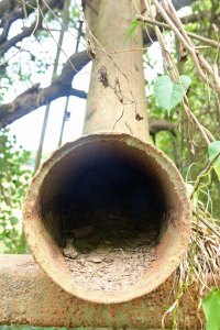
In an overgrown corner of the Duck Pond, under a mature camphor laurel tree, close to the river and Ostrom Street, is a large wooden barge that was apparently known as the Bungawalbin, in a slow process of disintegration. Close by is a rusting hopper elevated on metal stilts, once fed by a wide-diameter inlet pipe that ran in from to the river and which has long since disappeared. It seems remarkable that these remnants of Lismore’s industrial history sit here, almost universally unacknowledged and unrecognised for what they are.
The South Lismore Duck Pond Landcare group meets regularly for working bees, and the best way to stay in touch with them is by liking their Facebook page.
Thanks for an engaging paper on the Duck Pond. I would like to visit the Duck pond with your notes as a vade mecum but am unable to print them, possibly because of a barrier in the Facebook system.
if you have printed copies perhaps I could buy one from you?
James Yeo
LikeLike
Hi James, if you’re able to, the easiest solution would be to cut and paste the text into Word or Open Office (a free equivalent of Word), and then print from there. Otherwise, I can post you a copy, which will be free of charge. If you’d like it posted, then please email me your postal address to uniquelynorthcoast@gmail.com
LikeLike
it’s all fine now thanks. I have followed your suggestion with gratifying result. Your posting offer is appreciated and declined with thanks. Best wishes for the future of your work,
Jim Yeo.
LikeLike
the good old duck pond. we used to swim and jump off the barge there and that was over 30 years ago
LikeLike
It’s great to hear some more stories about the place.
LikeLike
Thanks for this fascinating piece of local history, about a park (-like) area I’ve driven past a hundred times – without ever knowing it was there. I now want to at least drive down Ostrom St to have a look at it, and maybe stroll around too.
LikeLike
Thanks for the positive feedback, and I hope you enjoy your exploration.
LikeLike